This function runs the EPGM model for a specific simulated period. The model is based primarily upon data collected in the early 1990's along the phosphorus gradient in WCA-2A. Substantial additional data collected since then in WCA-2A and other locations indicate a need to recalibrate the model and potentially revise its structure. Recent data suggest, for example, that the relationship between cattail density and soil P needs recalibration and that actual soil P thresholds for biological impacts are probably lower than reflected in the original calibrations. There are also issues relating to interpretation of and potential anomalies in the historical soil P calibration data attributed to variations in soil core collection method and definition of the soil/water interface (inclusion vs. exclusion of floc layer). There are also indications in the recent data of biologically-mediated vertical transport and/or mixing that are not reflected in the current model structure.
EPGMProfile(
  case.no = NA,
  Start.Discharge = NA,
  STA.outflow.TPconc = NA,
  STA.outflow.vol = NA,
  FlowPath.width = NA,
  Hydroperiod = NA,
  Soil.Depth = NA,
  Soil.BulkDensity.initial = NA,
  Soil.TPConc.initial = NA,
  Vertical.SoilTPGradient.initial = NA,
  Soil.BulkDensity.final = NA,
  PSettlingRate = NA,
  P.AtmoDep = NA,
  Rainfall = NA,
  ET = NA,
  Yr.Display = 30,
  Max.Yrs = 200,
  Max.Dist = 15,
  Dist.increment.km = 0.1,
  plot.profile = TRUE,
  raw.output = FALSE,
  results.table = TRUE,
  summary.distance = c(0, 0.5, 1, 2, 4, 8, 10)
)
Arguments
| case.no | Case number from the pre-loaded example data (values ranges from 1 to 12) |
|---|---|
| Start.Discharge | The year which this particular STA began discharge operations. |
| STA.outflow.TPconc | Outflow total phosphorus concentration (in ug L-1; micrograms per liter) for this STA. |
| STA.outflow.vol | Annual outflow discharge volume (in x1000 Acre-Feet Year-1) for this STA. |
| FlowPath.width | The width of the downstream flow path (in kilometers). |
| Hydroperiod | Average hydroperiod (time above ground surface) of the downstream system (in percent). |
| Soil.Depth | Depth of soil (in centimeters). |
| Soil.BulkDensity.initial | The initial bulk density prior to dicharge of the soil downstream of the system (in g cm-3). |
| Soil.TPConc.initial | The initial total phosphorus concentration of soil prior to discharge downstream of the system (in mg kg-1). |
| Vertical.SoilTPGradient.initial | The soil total phosphorus concentration gradient prior to dischage downstream of the system (in mg cm-3 cm-1). |
| Soil.BulkDensity.final | The final bulk density after dischage of the soil downstream of the system (in g cm-3). |
| PSettlingRate | The phosphorus settling rate estimated from steady-state conditions (m Year-1). |
| P.AtmoDep | Phosphorus atmospheric depostition loading rate (in mg m-2 Year-1). |
| Rainfall | Annual accumulated rainfall estimate (m Year-1). |
| ET | Annual evapotranspiration estimate (m Year-1). |
| Yr.Display | Output displays results for this time (years) |
| Max.Yrs | Maximum number of years simulated |
| Max.Dist | Maximum ditance plotted, default is 50 km |
| Dist.increment.km | Distance increment modeled |
| plot.profile | If |
| raw.output | If |
| results.table | if |
| summary.distance | Default is |
Value
This function computes and plots the distance profile along the gradient based on input values
Details
As described in the original documentation, the model is designed to simulate marsh enrichment (responses to increasing P load), not recovery (responses to decreasing in load).
Examples
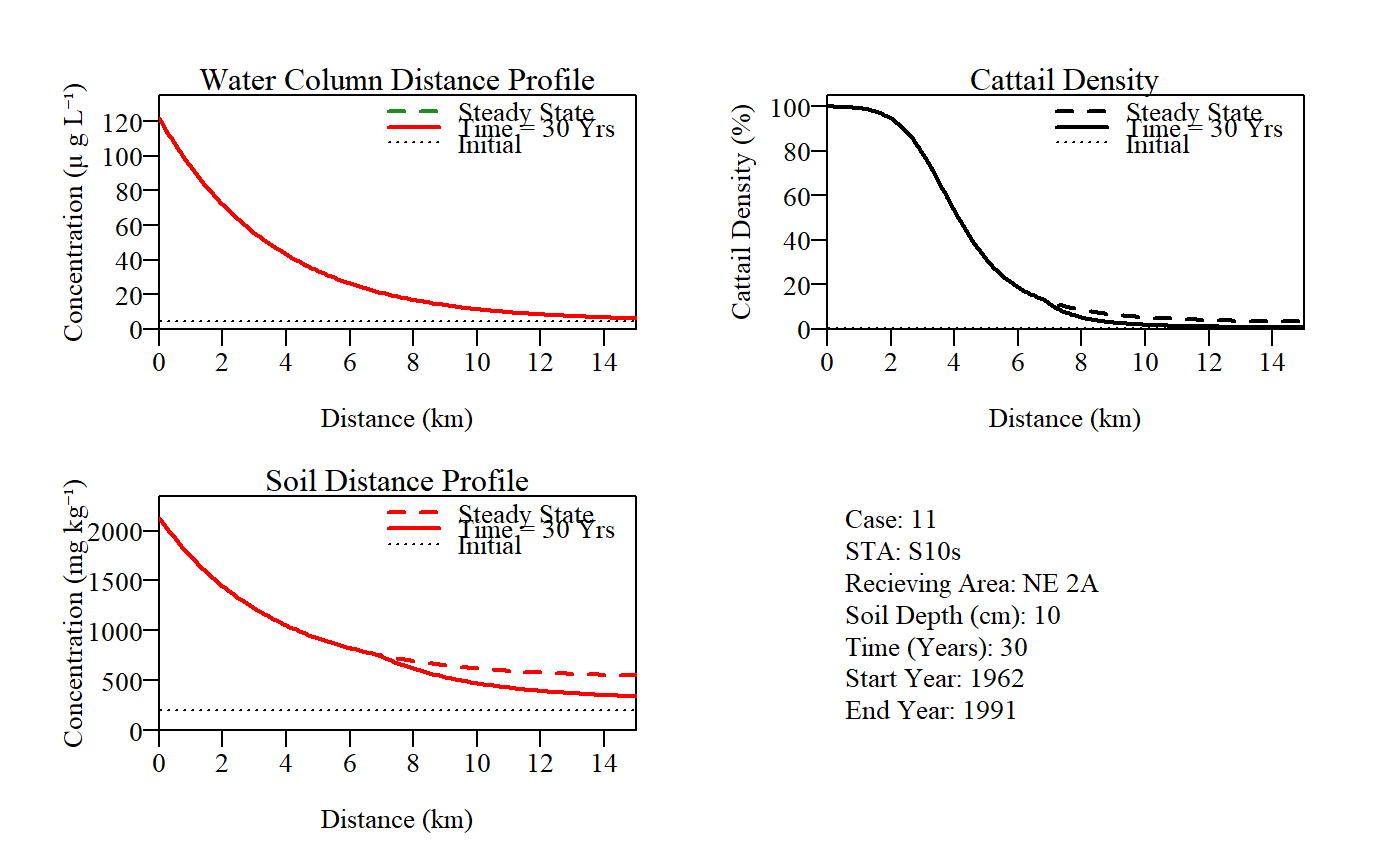
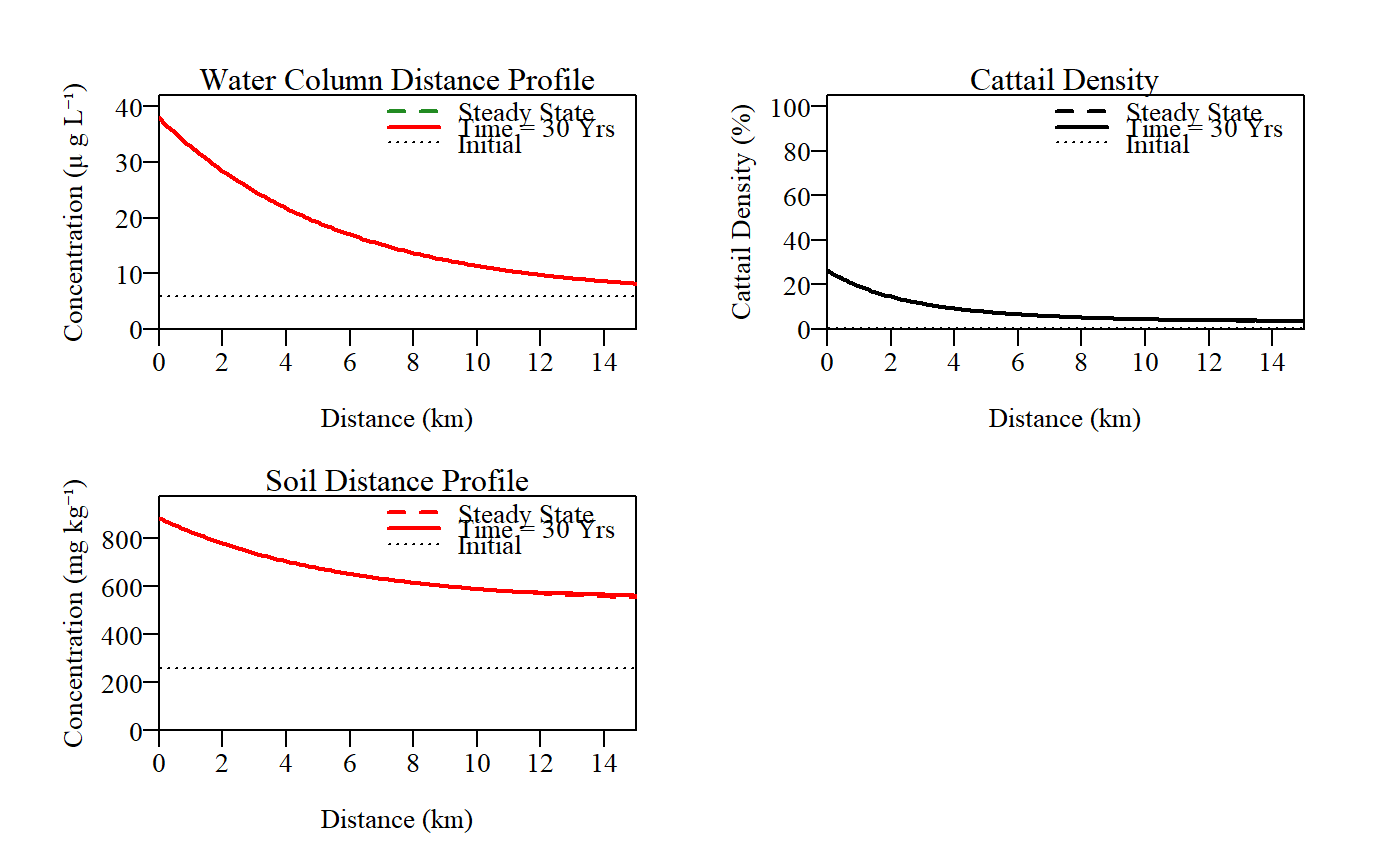
EPGMProfile(case.no=11)#> Warning: conversion failure on 'Concentration (μ g Lâ»Â¹)' in 'mbcsToSbcs': dot substituted for <e2>#> Warning: conversion failure on 'Concentration (μ g Lâ»Â¹)' in 'mbcsToSbcs': dot substituted for <81>#> Warning: conversion failure on 'Concentration (μ g Lâ»Â¹)' in 'mbcsToSbcs': dot substituted for <bb>#> Warning: conversion failure on 'Concentration (mg kgâ»Â¹)' in 'mbcsToSbcs': dot substituted for <e2>#> Warning: conversion failure on 'Concentration (mg kgâ»Â¹)' in 'mbcsToSbcs': dot substituted for <81>#> Warning: conversion failure on 'Concentration (mg kgâ»Â¹)' in 'mbcsToSbcs': dot substituted for <bb>#> $Time.yrs #> [1] 30 #> #> $Simulated.Zone #> Parameter Value #> 1 Distance.km 15.0 #> 2 Width.km 10.5 #> 3 Area.km2 157.5 #> 4 STA.outflow.volume.kAcftyr 281.3 #> 5 Hydroperiod.pct 91.4 #> 6 Soil.Depth.cm 10.0 #> 7 P.Settle.Rate.myr 10.2 #> 8 STA.outflow.Conc.ugL 122.0 #> 9 STA.outflow.Load.mtyr 42.4 #> #> $DistanceProfile #> 0 0.5 1 2 4 8 #> WaterCol.Pconc.ugL 122.00 106.90 93.70 72.10 43.10 16.90 #> SteadyState.WC.Conc.ugL 122.00 106.90 93.70 72.10 43.10 16.90 #> SteadyState.Soil.Conc.mgkg 2131.00 1925.00 1744.00 1449.00 1053.00 694.00 #> Time.to.Steady.State.yrs 15.00 15.50 16.00 17.20 20.90 35.20 #> NewSoil.Depth.cm 10.00 10.00 10.00 10.00 10.00 8.50 #> Soil.Mass.Accret.kgm2yr 0.67 0.65 0.63 0.58 0.48 0.28 #> Cattail.Density.pct 100.00 100.00 99.00 95.00 53.00 5.00 #> SteadyState.Cattail.Density.pct 100.00 100.00 99.00 95.00 53.00 9.00 #> 10 #> WaterCol.Pconc.ugL 11.50 #> SteadyState.WC.Conc.ugL 11.50 #> SteadyState.Soil.Conc.mgkg 620.00 #> Time.to.Steady.State.yrs 46.30 #> NewSoil.Depth.cm 6.50 #> Soil.Mass.Accret.kgm2yr 0.22 #> Cattail.Density.pct 2.00 #> SteadyState.Cattail.Density.pct 5.00 #> #> $Water.Budget #> Total.Flow.m Total.Flow.hm3 Sim.Avg.Flow.myr #> Inflow 66.14 10417 2.20 #> Rainfall 34.80 5481 1.16 #> ET 41.40 6520 1.38 #> Outflow 59.54 9378 1.98 #> #> $P.MassBalance #> PMass.mgm2 PMass.mtons Sim.Avg.Load.mgm2yr #> Inflow 8069 1270.9 269.0 #> Rainfall 1493 235.1 49.8 #> Removal 8986 1415.3 299.5 #> Outflow 576 90.7 19.2 #> #> $Soils #> SoilMass.kgm2 PMass.mgm2 PConc.mgkg BulkDensity.gcm3 PVol.mgcm3 #> Initial Storage 10.20 2020 198 0.102 0.020 #> Current Storage 8.46 6761 800 0.085 0.068 #> Accretion 8.22 8986 1093 0.080 0.087 #> Burial 9.97 4245 426 0.097 0.041 #>EPGMProfile(NA,1991,38,526,15.3,50,10,0.05,257,-0.004,0.04,15.2,45,1.3,1.4)#> Warning: conversion failure on 'Concentration (μ g Lâ»Â¹)' in 'mbcsToSbcs': dot substituted for <e2>#> Warning: conversion failure on 'Concentration (μ g Lâ»Â¹)' in 'mbcsToSbcs': dot substituted for <81>#> Warning: conversion failure on 'Concentration (μ g Lâ»Â¹)' in 'mbcsToSbcs': dot substituted for <bb>#> Warning: conversion failure on 'Concentration (mg kgâ»Â¹)' in 'mbcsToSbcs': dot substituted for <e2>#> Warning: conversion failure on 'Concentration (mg kgâ»Â¹)' in 'mbcsToSbcs': dot substituted for <81>#> Warning: conversion failure on 'Concentration (mg kgâ»Â¹)' in 'mbcsToSbcs': dot substituted for <bb>#> $Time.yrs #> [1] 30 #> #> $Simulated.Zone #> Parameter Value #> 1 Distance.km 15.0 #> 2 Width.km 15.3 #> 3 Area.km2 229.5 #> 4 STA.outflow.volume.kAcftyr 526.0 #> 5 Hydroperiod.pct 50.0 #> 6 Soil.Depth.cm 10.0 #> 7 P.Settle.Rate.myr 15.2 #> 8 STA.outflow.Conc.ugL 38.0 #> 9 STA.outflow.Load.mtyr 24.7 #> #> $DistanceProfile #> 0 0.5 1 2 4 8 #> WaterCol.Pconc.ugL 38.00 35.30 32.80 28.50 21.70 13.70 #> SteadyState.WC.Conc.ugL 38.00 35.30 32.80 28.50 21.70 13.70 #> SteadyState.Soil.Conc.mgkg 887.00 856.00 829.00 780.00 705.00 615.00 #> Time.to.Steady.State.yrs 12.30 12.80 13.30 14.40 17.10 23.70 #> NewSoil.Depth.cm 10.00 10.00 10.00 10.00 10.00 10.00 #> Soil.Mass.Accret.kgm2yr 0.81 0.78 0.75 0.69 0.59 0.42 #> Cattail.Density.pct 26.00 23.00 19.00 15.00 9.00 5.00 #> SteadyState.Cattail.Density.pct 26.00 23.00 19.00 15.00 9.00 5.00 #> 10 #> WaterCol.Pconc.ugL 11.40 #> SteadyState.WC.Conc.ugL 11.40 #> SteadyState.Soil.Conc.mgkg 589.00 #> Time.to.Steady.State.yrs 27.30 #> NewSoil.Depth.cm 10.00 #> Soil.Mass.Accret.kgm2yr 0.37 #> Cattail.Density.pct 4.00 #> SteadyState.Cattail.Density.pct 4.00 #> #> $Water.Budget #> Total.Flow.m Total.Flow.hm3 Sim.Avg.Flow.myr #> Inflow 84.88 19480 2.83 #> Rainfall 39.00 8950 1.30 #> ET 42.00 9639 1.40 #> Outflow 81.88 18791 2.73 #> #> $P.MassBalance #> PMass.mgm2 PMass.mtons Sim.Avg.Load.mgm2yr #> Inflow 3225 740.2 107.5 #> Rainfall 1755 402.8 58.5 #> Removal 3908 896.9 130.3 #> Outflow 1073 246.2 35.8 #> #> $Soils #> SoilMass.kgm2 PMass.mgm2 PConc.mgkg BulkDensity.gcm3 PVol.mgcm3 #> Initial Storage 5.00 1285 257 0.050 0.013 #> Current Storage 4.02 2633 655 0.040 0.026 #> Accretion 5.72 3908 684 0.040 0.027 #> Burial 6.70 2560 382 0.047 0.018 #>