
Water Level Limbo
Finding Lake O’s Water Level Sweet Spot
Keywords: Okeechobee, water level, LOSOM
Original article published as a SCCF Wednesday Update.
When it comes to water, Florida has two seasons: wet and dry. This seasonality in rainfall causes water levels within lakes and wetlands to fluctuate with large seasonal and within-year (intra annual) variability that can affect ecosystem function and structure. This is especially true for Lake Okeechobee, the largest freshwater lake in the Southeast. Lake Okeechobee supports a large freshwater recreational fishery and is an integral part of South Florida’s hydroscape.
Lake Okeechobee is the beating heart of the Everglades. Throughout the seasons, water levels rise and fall, providing freshwater to the downstream Everglades and coastal estuaries. Historically, this large, shallow lake would overflow to the south and west during periods of high water, providing a sheetflow of water to the south into the Everglades. To the west, Lake Okeechobee’s littoral zone (nearshore area from the high-water line occupied by wetlands) adapted to high and low water events by expanding and contracting across the landscape. As extensive levee, canal, and lock/gate systems were constructed around the lake in the early and mid-1900s, the lake became encircled by infrastructure. This infrastructure ultimately isolated the lake’s littoral zone to a fraction of its historic size.
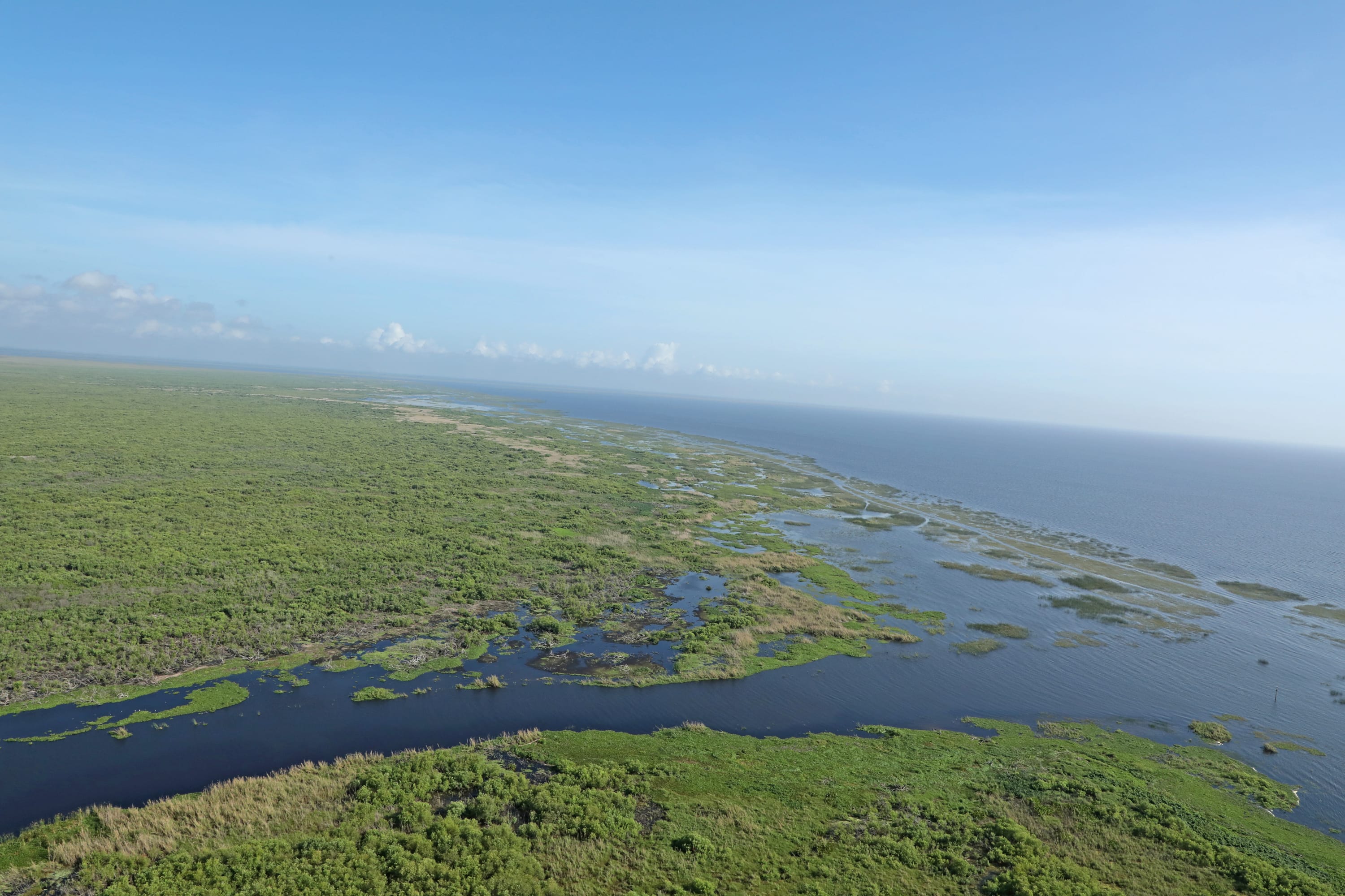
Photo Credit: Charles Hanlon, South Florida Water Management District Edge of the littoral zone at Cochrans Pass (April 2021).
Since being impounded more than 60 years ago, water levels within Lake Okeechobee have been managed in part by the U.S. Army Corps of Engineers through a series of regulation schedules. Under these regulation schedules, Lake Okeechobee has experienced periods of extreme high and low water conditions, which has resulted in detrimental effects to the near-shore ecosytems.
Across the lake, high water levels can negatively impact plants and animals due to deep water, flooding of the littoral zone, erosion, nutrient transport, and algae blooms. Low water levels can dry out portions of the littoral zone, spread exotic species, impact the fishery, and reduce prey for snail kites and alligators. Moderate water levels—“the sweet spot”—can provide optimal recruitment of the fishery, provide ample forage for wading birds and snail kites, and allow for plants to proliferate across the lake.
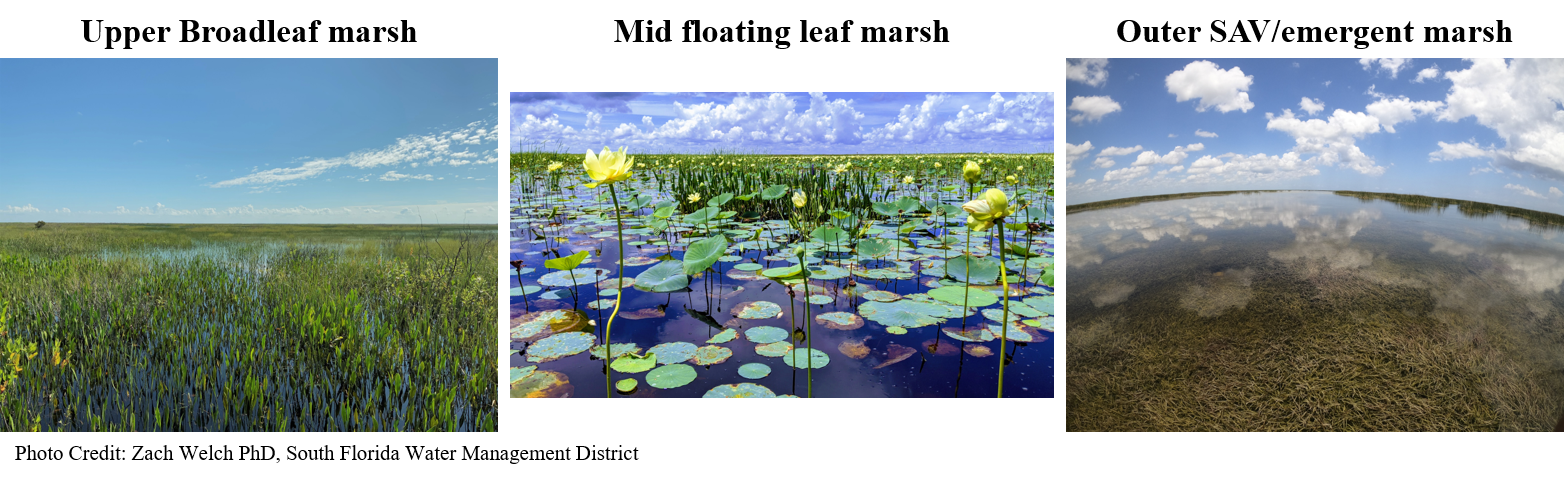
The littoral zone of Lake Okeechobee is composed of a variety of different plant species all adapted for different growing conditions. From left to right: an upper broadleaf marsh system, mid-level floating leaf marsh, and an outer submerged and emergent vegetation marsh. Photo Credit: Zach Welch
Efforts are underway to revisit the Lake Okeechobee System Operating Manual and revise how water is managed for Lake Okeechobee. With the recent completion of the Herbert Hoover Dike improvements, a greater range of water levels can be exercised in Lake Okeechobee. Currently, all of the alternative plans proposed by the U.S. Army Corps of Engineers, which manages the lake, intend to keep the lake higher than existing conditions. (However, as previously noted, high water levels can have harmful effects on the lake’s overall health.) Some plans add an extra foot to water levels and reduce the amount of time it is within the moderate, sweet spot, level.
High and low water levels can be tolerated for short periods of time, and sometimes are needed for the ecology of the lake, but prolonged and extreme events can cause significant ecological consequences and impact water quality within the lake. How a prospective plan manages these events is important. Ultimately, a plan that optimizes water levels for the ecology of the lake is needed—and this has to be done in a way that minimizes the damaging discharges to coastal estuaries.
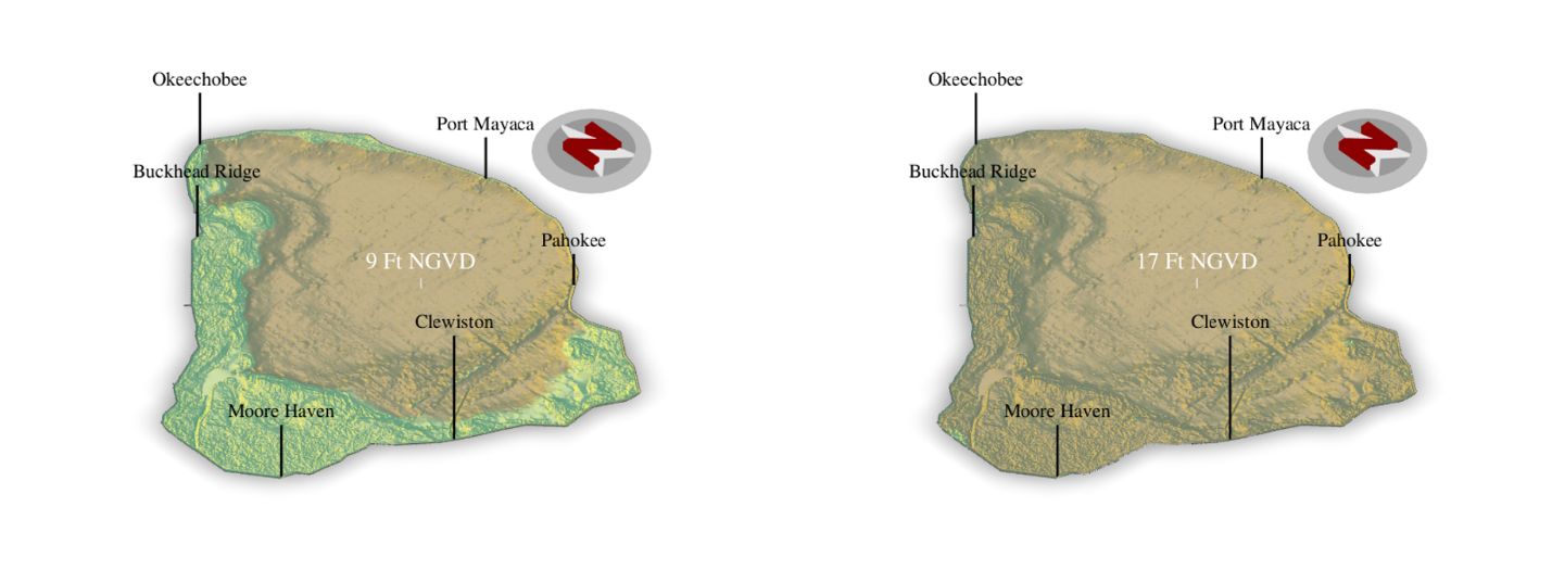
Lake Okeechobee at 9 and 17 feet National Geodetic Vertical Datum (NGVD) of 1929. Water levels on the lake are measured relative to sea level, NGVD 1929 is the vertical datum used by the South Florida Water Management District and U.S. Army Corps of Engineers.
Hydrologic Modeler Paul Julian’s position is funded jointly by SCCF and The Conservancy of Southwest Florida.
Want to know more about SCCF? Visit our webpage.
More information on LOSOM can be found at the USACE LOSOM project webpage